
Commission - Jun 02, 2026 - Meeting
Commission • San Francisco Bay Conservation and Development CommissionJune 2, 2026
Locunity is a independent informational service and is not an official government page for this commission.We use AI-assisted analysis and human editorial review to publish information.
Berkeley Pier Project Clears Engineering Review With Seismic, Coastal Questions Unresolved
The San Francisco Bay Conservation and Development Commission's Engineering Criteria Review Board spent more than two hours drilling into the technical design of Berkeley's $130 million-plus pier and ferry terminal project — then unanimously agreed to let it move forward with five outstanding questions to be resolved outside the public meeting room.
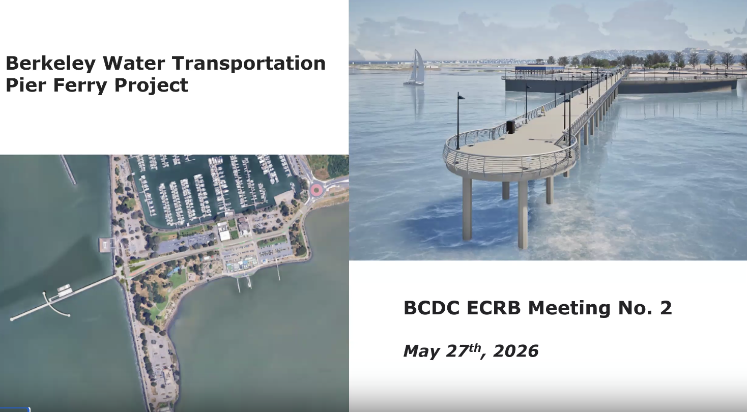
- Berkeley's new 1,080-foot pier, breakwater, and ferry terminal project advances past second ECRB review on an 8-0 vote
- Board flags Hayward Fault directivity, novel pile sleeve stability, and wave height methodology as unresolved engineering concerns
- Coastal engineer urges project team to use local Berkeley Reef wind data for a $130M+ critical infrastructure investment
- BCDC attorney clarifies sub-quorum consultation rules, enabling staff to tap up to four board members per technical discipline for follow-up
- New BCDC engineer McKenna Wong takes over engineering review duties from retiring Leslie Ewing
Five Questions, No Guarantee of Another Hearing
Why it matters: The City of Berkeley is seeking to replace its closed pier with a new 1,080-foot structure, a 300-foot breakwater, and a ferry terminal designed as essential post-earthquake emergency infrastructure. The project would restore public waterfront access and create a new SF Bay Ferry landing. At a price tag exceeding $130 million, the engineering decisions made now will shape the structure's resilience for decades.
Where things stand: This was the project's second appearance before the ECRB, following a February 2025 session that generated a long list of technical questions. James Connolly, COE marine structural engineer and project manager, returned with his team to present follow-up responses on seismic codes, wave analysis, slope stability, the pile sleeve design, and sea level rise criteria.
The project has formally adopted ASCE 7-22 seismic building code standards alongside ASCE 61-14 (the primary coastal structures standard) and the intermediate-high sea level rise scenario. The design team also performed a preliminary check against the draft ASCE 61-26, which governs a 975-year seismic event — though Connolly noted limitations. "We have a draft copy. The draft copy very clearly says, public comment, draft, do not use or cite. So we have certain restrictions about how far we feel we can push this as far as formally adopting it as a criteria," said James Connolly, COE marine structural engineer.
The pier elevation is set at 17.6 feet — 6 feet higher than the current pier and approximately 2 feet higher than the San Francisco Ferry Terminal expansion, making it the highest ferry pier in the Bay Area. But further elevation increases are constrained by two factors: the shore side must tie into the existing University Avenue/Seawall Drive roadway at elevation 14.8 feet while maintaining ADA-compliant grades, and the 120-foot gangway to the float already approaches the extreme length for aluminum construction.
Decisions: After extended deliberation, Board Member Nick Sitar moved a substitute motion to accept the presentation, note progress, and list five outstanding items for resolution: navigability through the dredge channel, sedimentation management behind the breakwater, sleeve installation stability and failure mode analysis, seismic design and directivity effects, and consideration of additional wind data. Vice Chair Jim French seconded.
The motion passed 8-0 on roll call (For: Awasko, French, Casale, Ryan, Golisorski, Sitar, Johnson, Vanderhoor; Against: 0; Absent: 0). Critically, the motion does not require another full ECRB hearing — follow-up submissions will be reviewed by BCDC staff, who may consult up to four board members per technical discipline. Another meeting will be called only if significant concerns arise.
"I am very hesitant to say that we are the final, final arbiter of whether something is right or wrong," said Chair Rod Awasko, framing the board's role as raising questions about criteria and due diligence rather than certifying designs.
What's next: The City of Berkeley's design team will submit additional documentation on the five follow-up items. BCDC staff will review and may consult with subsets of ECRB members, with a possible but not guaranteed return to the full board.
Hayward Fault Directivity: The Seismic Question That Won't Go Away
The basics: The Berkeley Pier sits roughly 5 to 6 kilometers from the Hayward Fault and is oriented nearly perpendicular to it — a geometry that can amplify seismic ground motion in one direction through a phenomenon known as near-source directivity.
Why it matters: The standard seismic spectrum used by the design team (RotD50) represents an average across all directions. Board Member Ramin argued this does not capture velocity pulses in the maximum direction, which could be 20–25% higher in the 1-to-2-second period range relevant to the structure.
"We are about between five to six kilometers away from Hayward. This structure is pretty much perpendicular to Hayward for all practical purposes," Board Member Ramin said, pressing the design team on whether maximum-direction factors had been applied.
Geotechnical Engineer Jeff Phippen confirmed the team developed a site-specific spectrum under ASCE 7-22 but did not add maximum-direction factors. Ramin raised a second concern: potential double-counting of damping when ductility-based response reduction is combined with a reduced damping spectrum. "If you get ductility and that's based on a demand and then you take a damped spectrum on top of that, it seems double counting to me," he said.
The design team committed to providing additional documentation. This item is one of the five flagged for staff-level follow-up.
Pile Sleeve Innovation Draws Scrutiny and a Loma Prieta Warning
The basics: The most landward pier piles pass through a stiff rock dike before reaching the softer bay mud where the remaining piles are founded. To make all piles behave consistently during an earthquake, the design team developed a novel sleeve — essentially a 54-inch-diameter tube (increased from 36 inches based on earlier ECRB feedback) — to isolate the landward piles from the dike material.
Why it matters: If the sleeve fails, the near-shore piles could respond very differently from the offshore piles during a seismic event, potentially compromising the structure's essential-facility designation for post-earthquake emergency ferry service.
Vice Chair Jim French raised multiple potential failure modes — tipping, settlement, wave action loosening, and construction tolerances — and requested a formal failure mode analysis. He also invoked a cautionary precedent: during the 1989 Loma Prieta earthquake, piles at Berth 37 at the Port of Oakland cracked at the boundary where soil stiffness changed abruptly. "Something like a third of them that were in that row approximately corresponding to where your sleeves are, were cracked at that impedance change at the bottom of bay mud to stiff sands," he said.
Connolly defended the design, noting the existing shoreline has been stable for more than 60 years with rock armor protection, and that the sleeve would be embedded approximately 15–16 feet through the rock dike with only 1–3 feet exposed.
French ultimately softened his concern after reviewing cross-section details: "Having looked at slide 22 with regard to that whole sleeve discussion, it looks better than what I was concerned about. So I think most of my worries are minor at this point." Still, the board listed sleeve stability and a failure mode analysis as a formal follow-up item.
Wave Heights and Wind Data: A $130M Disagreement
Why it matters: If wave heights at the pier site are underestimated, the breakwater may not sufficiently protect the ferry terminal from northwest winds, increasing service downtime at a facility designated as critical infrastructure.
Where things stand: The design team used a 27-year hindcast with wind data from three nearby stations and Mike21 modeling. Their analysis produced a significant wave height of 2.6 feet, corresponding to a maximum wave height of 4.7 feet for structural loading. Board Member Justin noted the FEMA regional model (built by DHI using more distant airport wind stations and longer records) showed 7 to 8 events exceeding that 2.6-foot threshold. He supported the design team's choice of closer stations as a "fair argument" but distinguished between operational and structural implications: "In those conditions of strong wind and waves, the ferries might not be operating anyway. So I think there's like these operational considerations that are maybe separate from the wave design criteria for the structure itself."
The other side: Jim McGrath, a coastal engineer who spoke during public comment, pushed harder. He urged the project team to incorporate Berkeley Reef wind station data, noting daily winds exceeding 25 mph and significant northerly winds that the breakwater — reduced from 400 to 300 feet and oriented to the northwest — does not protect against. McGrath emphasized that over six years of Berkeley Reef data are available and were used in initial technical studies.
The design team responded that even with higher wave estimates, structural elements are primarily governed by seismic rather than wave loads. Connolly noted wave forces on pier piles calculate to about 5 kips each, compared to roughly 120 kips from seismic shear — orders of magnitude apart. Consideration of additional wind data is among the five follow-up items.
Sedimentation: An Inevitable Cost Nobody Has Budgeted
Board Member Nick Sitar flagged what he called an inevitable operational challenge: sedimentation behind the breakwater. Building a 300-foot structure in the Bay will alter current patterns and trap sediment, requiring ongoing maintenance dredging.
"I would suggest that BCDC should be thinking about it because it will happen. It's not — it may happen. It will happen," Sitar said, pressing the point as both an engineering and a long-term cost issue. Navigability through the dredge channel and sedimentation management are both among the five items flagged for follow-up.
Minor Items
-
New BCDC engineer introduced. Leslie Ewing, serving as part-time interim engineer following Jen Hyman's retirement, introduced McKenna Wong as BCDC's permanent engineer. Wong previously led 30% design of sea level rise adaptation along 3 miles of San Mateo County shoreline at One Shoreline and holds a master's degree from Stanford. She will manage future ECRB reviews.
-
Legal training on open meeting rules. Senior Staff Attorney Michael Ng walked the board through Bagley-Keene Open Meeting Act requirements, serial meeting prohibitions, ex parte communication rules (applied to ECRB members since 2021), and conflicts of interest. He confirmed that staff can engage separate subgroups of fewer than five members on different technical questions without triggering a quorum violation — directly enabling the Berkeley project follow-up process. "I don't think you could then attribute what the four or less geotechnical engineers happen to think or say about the topic specifically to the ECRB, because that's not a quorum of the ECRB," Ng said.
-
June meeting canceled. The next ECRB meeting is tentatively scheduled for July 22.
-
ECRB informational pamphlet distributed. An updated pamphlet explaining the board's purpose and meeting process was shared with members.