
City Council - Jun 09, 2026 - Special Meeting
City Council • El CerritoJune 9, 2026
Locunity is a independent informational service and is not an official government page for this commission.We use AI-assisted analysis and human editorial review to publish information.
El Cerrito Weighs District Maps as San Pablo Corridor Divides Council
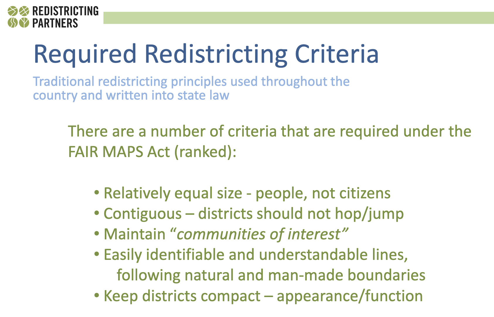
El Cerrito's mandatory shift from at-large to district-based elections hit its most consequential moment yet, as the City Council reviewed three draft maps that would redraw political representation for 26,000 residents over the next decade. The sharpest debate centered on a deceptively simple question: should the San Pablo Avenue corridor — home to the city's densest concentration of renters, low-income residents and communities of color — stay unified in one district or be carved across several?
Three draft district maps unveiled, each splitting El Cerrito's five seats differently along school zones, compact shapes and communities of interest
San Pablo corridor renter community emerges as the defining fault line — council members and residents clash over whether to unify or split the city's most diverse neighborhood
Anonymous plaintiff drives 90-day timeline with no extensions granted, leaving just two hearings to finalize a map
New housing at Mayfair and Plaza BART complicates population math, raising questions about whether districts should be drawn smaller now to absorb growth
Six public commenters push for better outreach, warning that only about 10 communities of interest have been submitted citywide
Who Gets a Voice on San Pablo Avenue?
The El Cerrito City Council held its third of five required public hearings on the city's court-pressured transition to district-based elections, reviewing three draft maps and more than 27 public submissions — but the night's most consequential debate wasn't about lines on a map. It was about power: specifically, whether the renter-heavy, racially diverse San Pablo Avenue corridor would be kept whole as a political bloc or diluted across multiple districts.
The basics: The city received a demand letter on March 17 alleging racially polarized voting under the California Voting Rights Act. After its own statistical analysis found some basis for the claim, the Council entered the CVRA safe harbor process rather than litigate. No California city has ever successfully defended such a suit, and all have been required to pay the plaintiff's attorney fees — which can run into the hundreds of thousands of dollars. The plaintiff remains anonymous.
Why it matters: How the final map treats the San Pablo corridor will determine whether lower-income and BIPOC residents have a unified political voice or are spread thin across multiple districts for the next decade. The decision also sets the template for which three districts elect representatives in 2028 and which two follow in 2030.
Three Maps, Three Philosophies
Demographer Paul Mitchell of Redistricting Partners walked the Council through the three draft maps alongside the public submissions. Draft Map A, based on school attendance zones, carries a 5.5% total population deviation. Draft Map B, derived from public submission No. 48, features more compact shapes and a tighter 4% deviation. Draft Map C blends elements from multiple submissions to better preserve the hillside community and the San Pablo corridor.
"Draft Map B is based on a public submission number 48," said Mitchell. "It has a 4% deviation, whereas the one in 48 had a 9.9% deviation."
All three maps must divide the city's 26,000 residents into five districts of approximately 5,200 people each, with no more than 10% total population deviation — a requirement of the Fair Maps Act.
The San Pablo Corridor Fight
The most heated exchange came over the San Pablo Avenue corridor, a strip of concentrated rental housing running through the western part of the city. Public commenter Neil Tsutsui, an 18-year resident who created his own Map 109 after the June 2 submission cutoff, laid out the stakes bluntly: Maps A and C split San Pablo renters into three districts, while Map B fragments them across four.
Tsutsui's Map 109 achieves only a 1.53% population deviation, roughly follows elementary school boundaries, unifies the west-of-I-80 community, and provides representation for far northern El Cerrito. He asked that it be posted publicly for seven days before the next hearing.
Councilmember Carolyn Wysinger was the most forceful voice on the dais in favor of keeping renters unified.
"I want to make sure that's a very, very powerful community, a community that's probably going to have a lot of our low income, our BIPOC community on the other side of the freeway, that Potrero side that actually does have a lot of our longtime POC communities in that area," she said.
The other side: Public commenter Grant Ricketts took the opposite view, favoring Map B and arguing for splitting the San Pablo corridor into two districts rather than one. Ricketts also questioned why the city conceded to the demand letter at all, comparing CVRA plaintiffs to "patent trolls" and asking the Council to identify the anonymous complainant.
Mitchell agreed to provide renter-density data overlays in the online mapping tool before the next hearing, a move that could reshape which draft maps survive.
New Housing Throws a Wrench in the Math
Mayor Pro Tem Rebecca Saltzman raised a practical problem the maps don't yet account for: multifamily housing already built or under construction that could make population deviations worse by the next redistricting cycle in 2032.
"The Mayfair development, those units are already there. Most of them are occupied. The 70 units that are being built right now at Plaza BART, their affordable housing, they'll get occupied immediately," Mayor Pro Tem Saltzman said, suggesting districts with known incoming housing be drawn slightly smaller now.
Mitchell cautioned against overweighting visible development.
"The challenge is this, that we as human beings can be really bad at judging numbers sometimes like this, because it's the visible that we place a lot of priority on," he said, citing experience from Davis where anticipated growth didn't materialize as expected.
He recommended using new housing data as a tiebreaker at best, not as a primary driver of district boundaries.
The 90-Day Clock and the Anonymous Plaintiff
The City Attorney Sky Woodruff explained why the timeline is so compressed — and why it cannot be extended. The anonymous plaintiff's attorney refused all requests for additional time, even after the city pointed out that holding redistricting hearings simultaneously with a June election would cause public confusion.
"We pointed out how many other issues were occurring this summer, including the June election. We pointed out that this would cause confusion for people because we would be talking about council elections right before a council elections started. The attorney basically said that his client was indifferent to all of those things," Woodruff said.
Woodruff also warned that adopting a map that doesn't meet CVRA technical requirements could void the safe harbor protection entirely:
"If the maps selected do not meet the technical requirements of the CVRA, then the city is subject to an argument that it has not actually cured the alleged racially polarized voting that initiated the complaint in the first place."
Election Sequencing: A Hybrid 2028
Mitchell explained the mechanics of the transition. In 2028, three districts — the odd-numbered ones — will elect representatives under the new district lines. For 2029 and 2030, the city will operate under a hybrid system with three district-elected and two at-large council members. The remaining two districts will elect their representatives in 2030, completing the transition. Incumbents' current terms are protected.
Councilmember William Ktsanes asked whether sequencing was mandatory and raised concerns about voter confusion. Mitchell confirmed the sequenced approach is standard practice.
Public Pushes for Better Outreach
Several commenters expressed frustration that the process was moving fast with minimal public awareness. Richard Brooks urged viewers to search "El Cerrito districts," fill out the communities of interest form and spread the word, noting that only about 10 communities of interest had been submitted from a city of 26,000 residents. Rebecca Kenney echoed the concern, saying many residents in her neighborhood simply don't know the process is happening and urged more aggressive communication before the 2028 election.
Betsy Bashor asked practical questions about what a "hillside district" means, whether garbage collection zones could serve as district boundaries, and how the process prevents incumbent gerrymandering.
Saltzman reflected on the inherent awkwardness of the exercise.
"The thing that this process has shown me the most is this doesn't make any sense. Because, I mean, if I think about like my own communities of interest, they're really throughout the city," she said.
Decisions: The Council voted 4-0 by voice vote to close the public hearing, with Mayor Gabriel Quinto absent. No map was selected. The process continues at the next hearing, where the pool of maps will be narrowed.
What's next: The demographer will provide renter-density data overlays for the next hearing. With only two hearings remaining in the 90-day safe harbor window, the Council must narrow the field and ultimately adopt a final map — or face a lawsuit and potentially massive plaintiff attorney fees. The sequencing decision — which districts vote in 2028 versus 2030 — will be finalized only after a map is chosen.